| ECRC has developed
over 20 GIS maps as part of our ARID (Armenian Resource Information
Database) project. Many of our maps have been used in the State
of the Environment Report for Armenia. We are constantly adding
to and updating our collection. Click on a sample map below for an
enlarged view. |
|
|
 |
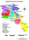
| Administrative districts
(Marzes) in the Republic of Armenia |
|
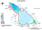
Historical water loss
and hydrological base map of Lake Sevan |

|
|
|
| Yerevan streets, rivers,
and landmarks |
|
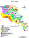
Major soil types of
the Republic of Armenia |
|
|
|
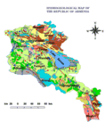
| Hydrogeological map
of Armenia |
|
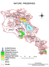
Nature preserves and
general topography of Armenia |